This is a universal device that serves not only for communication, but also for performing many other useful functions. One of the new features of the device is navigation. It became available thanks to the introduction of GPS sensors into the phone. How to choose and install navigator on smartphone?
GPS navigation on a smartphone
Most modern smartphones have built-in GPS sensors. This makes it easy to use your favorite device, for example, as car navigator to quickly find your way in unfamiliar places. It is very easy to take advantage of this opportunity.
With convenient apps install the navigator on a smartphone of any manufacturer possible in minutes. The only thing is that for different operating systems this process has its own nuances. Let's consider in more detail, how to use navigator in smartphone, and what programs are better to use for this.
Useful programs and applications: how to choose a navigator
Using a smartphone as a navigator made possible by the work of various programs and applications. They are of two types:
- Online (Yandex Navigation, Google Navigator and others);
- Offline (for example, Navitel).
The first option requires a mandatory Internet connection, so it is recommended to use them only with an unlimited tariff. A significant advantage of these programs is that they are regularly updated. In the basic version, these applications are free.
The second type of navigators can also be used when the Internet is turned off. All information is in the internal memory of the smartphone, however, it takes up quite a lot of space. These programs are paid.
Setting up the navigator on the base
Setting up a navigator for a smartphone on Android is very simple. You just need to download the desired program through the Play Market. The action plan is very simple and includes several actions:
- The first step is to create a Google account. This is necessary to work with the Play Market;
- Using the login and password of the account, you need to log in on your smartphone;
- Next, you need to launch the Play Market and select the desired application, for example Navitel. To speed up the process, you can specify its name in the search bar;
- When the application is displayed in the list of found ones, you need to click on its name and in the window that opens, click the "Run" button.
To use the navigator, you need to make sure that the GPS sensors are turned on. For example, for this you need to go to the "Settings" menu, select the "Location" item in it and configure the appropriate connection settings.
Android supports the following navigation apps:
- Navitel;
- 2gis;
Navigator selection based on
Now let's answer the question of how to set up a navigator on an iphone? The iOS operating system supports many navigators, including:
- Navitel;
- Navigon;
- CityGuide and others.
You can download the navigator for iphone, like other programs - through the App Store. You also need to download maps, as the pre-installed application is not always accurate.
To turn on GPS on your iPhone, you need to sequentially go to the "Settings", "Privacy" and "Geolocation" menus. In this section, you need to move the "Location Services" switch to the ON state.
Navigation based on Windows Phone
As a navigator in smartphones based on Windows Phone, for example, Lumia 640 using "Here" app. It allows you to view both a schematic map and a panoramic map with photos of houses. But you can also download another navigator through the Windows Store. The best options are:
- Yandex.Navigator;
- Navitel;
- 2 GIS;
- Windows Maps.
Knowing how to use a smartphone as a navigator, you can quickly get directions, find the nearest cafe or gas station, and determine the location of loved ones. And this is really a very useful and necessary feature for any smartphone owner.
Sooner or later, each of us has to travel to unfamiliar places, be it another city or some place outside of it. To navigate in space, there are many tools, such as a compass or a map. As for the city, usually people are guided by street names and house numbers. In extreme cases, you can always ask passers-by for directions.
However, these are too outdated methods of orientation, which are extremely inconvenient to use. Moreover, there are many modern technologies that can facilitate this task.
First of all, we should mention the so-called GPS navigators. This technology most reliably helps to navigate in space, and it is oriented, first of all, for car drivers.
As for pedestrians or cyclists, mobile devices with built-in GPS navigators can be considered the most convenient tool.
The most common gadget, at the moment, can be considered a smartphone on the Android operating system. Most of the devices on this system have complex specifications, including many modules and sensors. Among others, almost every device has a built-in GPS module. In fact, any smartphone can be turned into a GPS Navigator, albeit not as high quality as a full-fledged device.
When purchasing a new device, usually the operating system already has a built-in application for navigation, however, most often it is Google Maps, which, although easy to use, require the user to have a permanent connection to the Internet.
The Android operating system is good because you can install any software on it, at the discretion of the user.
First, you need to turn on the GPS module and, if possible, . Internet access will help you quickly connect to satellites and determine the approximate location.
Navigation is enabled in the system settings, namely, in the section " Location" or " Geolocation", may still occur" Geodata". To enable GPS navigation, you need to put the switch in the active position, after which you can see which applications have access to navigation services.


Another way to quickly turn on the navigation module is to open the curtain vertically from the top of the screen and click on the corresponding icon.


In the first section " Mode”, you can select the positioning accuracy and speed. Choosing the first item By GPS, Wi-Fi and mobile networks”, a person receives the fastest and most accurate connection to satellites, but at the same time, energy consumption and should be taken into account.

The slowest navigation is the determination of the user's location, only by GPS satellites.
Choosing and installing a third-party navigation app
As mentioned above, on any smartphone, be it iOS or Android, you can install a third-party application. For navigation in space, there are dozens of high-quality programs. Some applications are oriented for navigating the city and city roads, others for moving along intercity connections. There are also those who help specialists in complex, geodetic work.
As navigation satellites, American, Russian and Chinese satellites can be used, however, most smartphones use American GPS technology. If the smartphone supports other navigation systems, it will not be difficult for any program to connect to certain satellites.
One way or another, all navigation applications can be divided into two categories: those that work on a pre-compiled map and those that are positioned on satellite images. The most popular applications that work with satellite images are Google Maps and Yandex Maps. Both applications meet all the requirements, and yet, Yandex Maps is a more convenient application that allows you to save the entire previously displayed route in memory.
As the main program for moving on the roads, it is worth stopping your attention on the paid Navitel application.
Like any other application, Navitel is downloaded from the Play Store. After installing and running the program, a special directory " NavitelContent". Inside this folder, there is another directory called "Maps". It is in this folder that new maps should be loaded.

After launch, the application automatically starts searching for satellites. When the smartphone connects with at least one satellite, the application will display the approximate location of the person on the map. The more satellites are involved, the more accurately the user's location will be determined. It should be recalled that the Navitel application is paid, but it's worth it.
Unlike the previous application, Yandex Maps is absolutely free. To get started, you just need to run the program and wait until the program loads the selected area.
Yandex Maps can work both in satellite mode and as a map. For offline operation, you can download a map of your hometown. Unlike many other navigators, the maps of this application are absolutely free.

In the satellite imagery mode, a person can move not only on roads, but also on other terrain, such as a field, lake or forest.
On the right side, there are keys for scaling the map. You should be extremely careful, because the same area, but with a different scale, will reload the location. Thus, the phone's memory will fill up pretty quickly.
Of course, it is best to use a phone with a permanent internet connection. At the same time, the created cache must be cleared regularly.
If a person wants to use a smartphone without access to the Internet, the cache of satellite images can be downloaded in advance, while setting the same scale.
Summing up, it should be noted that, if desired, Yandex Maps can be replaced by Google Maps, and Navitel, by any other free alternative, for example, 2Gis.
Thus, any smartphone can be turned into a powerful navigation device.
Good afternoon friends. Today we will talk about navigators installed on Android and working without the Internet. Needless to say, navigators have made life much easier for drivers in different countries. Many people simply stopped taking with them various atlases and road maps of different parts of the Earth.
But, navigators are not always at hand, which cannot be said about a mobile phone. Also, on the road, the Internet often disappears. Therefore, a decent number of navigator applications for Android have been developed that function without the Internet. By installing such software on your phone, you can choose the shortest and safest way to the desired place, including in an unfamiliar city or country. I suggest you check out 10 of these Android navigators of 2019 and choose the one you like best.
Sygic

This offer is very popular in many countries. But, many drivers have found that if the program is used for a long time, the information given is not entirely reliable. Most likely, some places on Earth simply stopped supporting this software.
But, despite this, Sygic is still one of the main leaders among offline navigator programs for smartphones. This application has a good design that does not tire the eyes and fingers. In addition, the program can function using only GPS, which makes it possible to work efficiently without a permanent connection to the Internet. The software updates its topographic bases for free in most regions of the Earth.
All in all, this app is one of the best choices for people who spend a decent amount of time on the go. Even if, for a number of reasons, GPS and the Internet stop working, thanks to the downloaded maps, people will be able to navigate the terrain. To get additional features, such as voice guidance and detailed instructions, you need to install the PRO version.
Download Sygic.
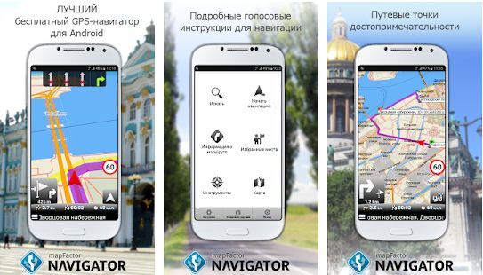
Until recently, this navigation program did not shine in a number of navigator programs. But, the developers of MapFactor began to make endless updates and improvements to the application. In total, this software took the top three among similar applications of the Android system.
Its main advantage is that by installing the program on a gadget, you no longer need the Internet for excellent navigation on the ground. It is only necessary to update the application every month, to replenish information about changes in cartography.
MapFactor has navigation routing in many languages of the world, and it is possible to design a route in advance. The program makes it possible to see the required route, both in 2D and 3D formats. That is, as a map with all the details, and in a simplified form.
For example, when traveling on freeways between cities, it is preferable to use simple maps, due to the fact that you just need to carefully observe the traffic. If you are in a populated area, it is better to use maps with all the nuances, such as gas stations, food outlets, rest and other landmarks.
Download navigator without internet for Android MapFactor.

Many users need to install a navigator on their phone. This is useful for couriers, taxi drivers, tourists and many other citizens. In modern realities, installing a navigator is very simple, so in this article we will analyze in detail how to install a navigator on an Android smartphone for free.
Which navigator to choose?
Before installing the navigator, you need to choose which navigator we will install. Currently available for Android 3 popular navigators: 2GIS, Yandex.Navigator and Google Maps. First, let's figure out what the difference is between these navigators.
2GIS - navigator without internet!
2GIS is currently outdated, it has extremely ill-conceived logistics, so it can sometimes start to drive you in circles.
The only advantage of this navigator is full performance without the Internet. You just need to download it, after which it will be able to work without the Internet.
Install 2GIS navigator:
- go to the Play Market, in the search, write "2GIS";
- go to the first application in the search and click the "DOWNLOAD" button;
- after that, the process of downloading city maps to the phone / tablet will begin;
- After downloading, you will be able to use 2GIS without the application.

Yandex.Navigator - online traffic situation!
The second navigator, Yandex.Navigator, is popular with transport drivers: taxi drivers, cargo carriers, etc. In addition, it is required to work with the Yandex.Taxi application.
This navigator has well thought out logistics, so it will show you both the shortest and the fastest way to bypass traffic jams and congestion. If you use a Yandex Phone phone, then this application will already be preinstalled for you.
If you have another smartphone, then you can go to play market, enter in search Yandex.Navigator, download the application, after which you can immediately use the navigator.

Google Maps - user-friendly interface!
The latest navigator Google Maps (Google Maps) offers a user-friendly interface, but unfortunately this application is extremely uncomfortable trips.
Maps are rarely updated, so they can lead you to a dead end. In addition, unlike Yandex.Maps, Google Maps does not show the real situation on the roads, so you will not be able to avoid a traffic jam or an accident if you drive on this map.
This navigator is preinstalled on all Android devices, just open the "Google" folder and open the Google Maps application there.

Guys, I already wrote that my friends are going to Europe by car and bought a DVR (read the review here) and a navigator, I will definitely take them before the trip, for testing. But here I had such a question - why buy if you have a phone? You know, I really thought about this question and it turns out that there is a sense. Read my thoughts...
In this article I will try to compare two "opposing" directions. On the one hand, these are phones and tablets (mobile devices that are always nearby), on the other hand, these are stationary navigators, many believe that their age is ending! But it seems to me that this is not entirely true. Let's start with phones and tablets.
Phones - tablets
There is nothing special to write about here. Of course, now on an android phone, namely, my friends have a lot of different navigation software, ranging from the same "NAVITEL" to various Yandex and Google maps and navigators (also on Apple and Windows).

On the one hand, this certainly pleases - it’s convenient, what can I say, I just activated the “geodata” (GPS) on the phone and laid the desired route. For a city, this is sometimes salvation, especially if you are in a foreign city.

THAT is an absolute plus is that the phone is always at hand, but is it so beautiful compared to a separate device, I mean with a stationary navigator?
Navigator
You know, I always watch taxi drivers, because they are the most professional drivers of all. They work on cars for a very long period of time, they know everything and everything in the structure of a car, they can keep up a conversation, they always have the latest information in their city, in general, people are “hardened” (experienced). So, 90% of taxi drivers always have a stationary navigator, and not on a phone or tablet.

Only 5% are found on mobile devices, why? There is a perfectly reasonable explanation for this. Here are a few items I picked up:
1) Price. If we talk about the cost, it turns out that the price of the navigator is slightly higher than the price of the navigation program itself. That is, if you buy the program locally on your phone, then the price is around 1800 rubles only for cards of Russia + another card of the country you need, another 800 rubles. And if you go to Finland. Then you need: 1800 rubles (Russia) + 800 rubles (Finland) = 2600 rubles. Whereas the navigator itself with all the maps will cost about 2900 rubles. Feel the difference?
2) satellites. One of the most basic points is working with satellites, that is, on many mobile devices, there is, as it were, a “positioning” (GPS) function, but it works via the Internet. And pure GPS may not be. Also, the work of “standalone” navigation systems can be difficult, because the processor is poorly optimized, the main power is “gobbled up” by other mobile applications, which can be very numerous, so navigation will be “side”.

Therefore, braking and freezing can occur here, especially on phones and tablets with low RAM. ON navigators, all the main power is given to the main task - GPS, and therefore the search for satellites and positioning on the ground will go faster.

3) Additional traffic. Follows from the second paragraph. It's no secret that the phone can download various data, such as traffic jams (and the cards themselves), via the Internet. Thus, if you call in a neighboring region (and even more so in another country), you can run into “wild roaming”, the money will fly away just at one time. Of course, you can turn off the Internet, but as a rule, many simply forget to do this, and when they remember it is too late. So, mobile Internet navigators have practically none. Now, of course, there are models with 3G, but buying a separate SIM card is not always advisable. This will save you from unnecessary expenses.

4) Convenience. If the navigator is turned on and the phone rings, then you need to plot the route again. As a rule, on some “weak” models, the program closes altogether, and you will need to start again. With all the consequences, and this is not good. What if they call you every few minutes? You will have to constantly "pull" the program!
5) Equipment. As a rule, navigators are already tuned for placement on a car, so they come with all kinds of mounts, on the windshield, or on the front panel. Whereas for a phone or tablet, they need to be bought in addition, and normal ones are not at all cheap.


6) Resource. As a rule, phones are not designed for many hours of navigation programs. They overheat, the batteries swell from this (tested on myself). As manufacturers recommend - continuous operation can be for 30 minutes, no more! What if you go to another city? YES, and if your battery "dies" - how much will a new one cost, moreover, if you have some kind of "top" model with a non-separable case? There, one work will be in the region of 1500 - 2000 rubles + the price of the battery itself. So you need to think about when to rape a phone or tablet like that.
7) Screen. Now navigators mostly have a 5-7 inch display, the resolution may be different, this is not the point - but it is made almost a square (well, or an unstretched rectangle) - for me personally, the perception is better. Phones also have a 5-inch display, but they are usually "stretched", which worsens the perception of maps.


8) Multimedia. Well, and probably the last one - many people think that navigators are a “stupid” device, which is sharpened only for navigation (although it seems to me that more is not needed). But this is not always correct - guys modern navigators, especially on android, can do everything you say, there is also video and photo viewing, there are also browsers, WIFI, etc. Although I emphasize once again that this is not necessary at all! But it's worth noting.